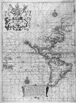
Edward Wright World Chart 1599
During the last 15 years, the author ahs researched and written extensively about eh faceted mosaic of documents it has taken to identify Captain Francis Drake's 1579 North American anchorage.
The Edward Wright world map 1599 was the only unpresented world chart or map to carry the Queen Elizabeth I Privy Seal during her reign. It was the 16th century's modern day GPS for navigation by the Queen's cartographer. It is the first chart by and Englishmen meant for navigation by Englishmen. It is only one of the indisputable clues that Nehalem Bay is where Captain Drake repaired the "Golden Hinde" during his 5-week summer sojourn in Oregon.
This map, combined with Edward Wright's "Certain Errors in Navigation" (1599) and compared with land survey Captain Drake laid out with incised rocks and cairns on Neahkahnie Mountain's countryside at 45 deg. 44 min. N. latitude, provides proof to the land claim that Capt. Drake called New Albion (old name for English soil) for his beloved Queen Elizabeth I and England.
(Only western hemisphere shown)